Spesial

Raksa

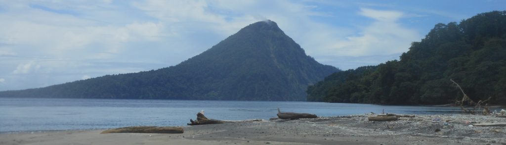
This peak is the highest point of the island of Panaitan off the remote south-western coast of Java in Ujung Kulon National Park. On the summit there is an early statue of the Hindu god Ganesha and the lingam symbol of shiva. The Ganesha statue is reportedly one of the oldest in Indonesia, possibly dating to 100 AD. Panaitan Island has outstanding wildlife and jungle – expect to see rusa deer, kancil (mouse deer), monkeys, python, and a wide variety of birdlife.

Raksa Read More »

Rakata

Facts Elevation: 813 m (2,667 ft) Prominence: 813 m Ribu category: Spesial Province: Lampung Google Earth: kml Rating: Other names: none Photos Bagging It! Rakata is the highest of the Krakatau islands in the Sunda Strait between Java and Sumatra. It is the remnants of the only one of three volcanoes (Perboewatan, Danan and Rakata)

Rakata Read More »

Burangrang

Facts Elevation: 2,064 m (6,772 ft) Prominence: 425 m Ribu category: Spesial Province: Jawa Barat (West Java) Google Earth: kml Rating: Other names: none. Photos Bagging It! Burangrang is the westernmost of the 2000-metre high peaks north of Bandung. Along with Tangkuban Parahu and Bukittunggul it is the remnants of the ancient Mount Sunda. Burangrang

Burangrang Read More »

Malabar (Puncak Besar)

Facts Elevation: 2,343 m (7,687 ft) Prominence: 714 m Ribu category: Spesial Province: Jawa Barat (West Java) Google Earth: kml Rating: Other names:none Photos Bagging It! This vast mountain area lies directly south of Bandung in Cisangkuy valley and is surrounded by a huge tea plantation – the largest in West Java. There used to

Malabar (Puncak Besar) Read More »

Rakutak

Rakutak is one of the lesser-known mountains in the Bandung area yet it offers excellent views across the region and is one of the nicest ridge walks in Java. It can easily be done as a day trip from Bandung, requiring just over 3 hours to ascend and 2 hours to descend. Our guide told us an interesting story about how, towards the end of the colonial era, local republicans climbed up Rakutak to escape from Dutch troops who then shelled it in an attempt to kill them.

Rakutak Read More »

Telomoyo

Facts Elevation: 1,894 m (6,214 ft) Prominence: 617 m Ribu category: Spesial Province: Jawa Tengah (Central Java) Google Earth: kml Rating: Other names: none. Photos Bagging It! This small mountain lies near Salatiga, to the north of the huge Merbabu mountain. It is very easy to ‘climb’ because there is a road to the communications

Telomoyo Read More »

Pulosari

This peak is the most popular climb in Banten. It is less prominent and less high than nearby Gunung Karang but is far more interesting as it features an impressive crater. There are great views from the summit ridge and it is a very easy hike – if you start early enough you can be back down in time for lunch. It is perfect as a last-minute day trip from Jakarta and takes just over two hours to reach by car.

Pulosari Read More »

Sorikmarapi

Facts Elevation: 2,145 m (7,037 ft) Prominence: 744 m Ribu category: Spesial Province: Sumatera Utara (North Sumatra) Google Earth: kml Rating: Other names: none Eruptions: 1879, 1892, 1893, 1917, 1970, 1986 Photos       Bagging It! This scenic volcano has 2 crater lakes – the largest of which is called Danau Merah – and is

Sorikmarapi Read More »

Iya

When people think of volcano attractions in Flores, they probably think of the Kelimutu lakes and perhaps Gunung Egon near Maumere. But perhaps the most impressive volcano on the island is Iya, a small peak at the end of a short peninsula just 15 minutes south by motorbike from the large town of Ende. Whereas Kelimutu has a carpark near the top and cement walkway to the rim, getting to Iya is a little harder and more dangerous than you would think just from looking at it on a map.

Iya Read More »

Scroll to Top